2026-27: Super El Niño Winter
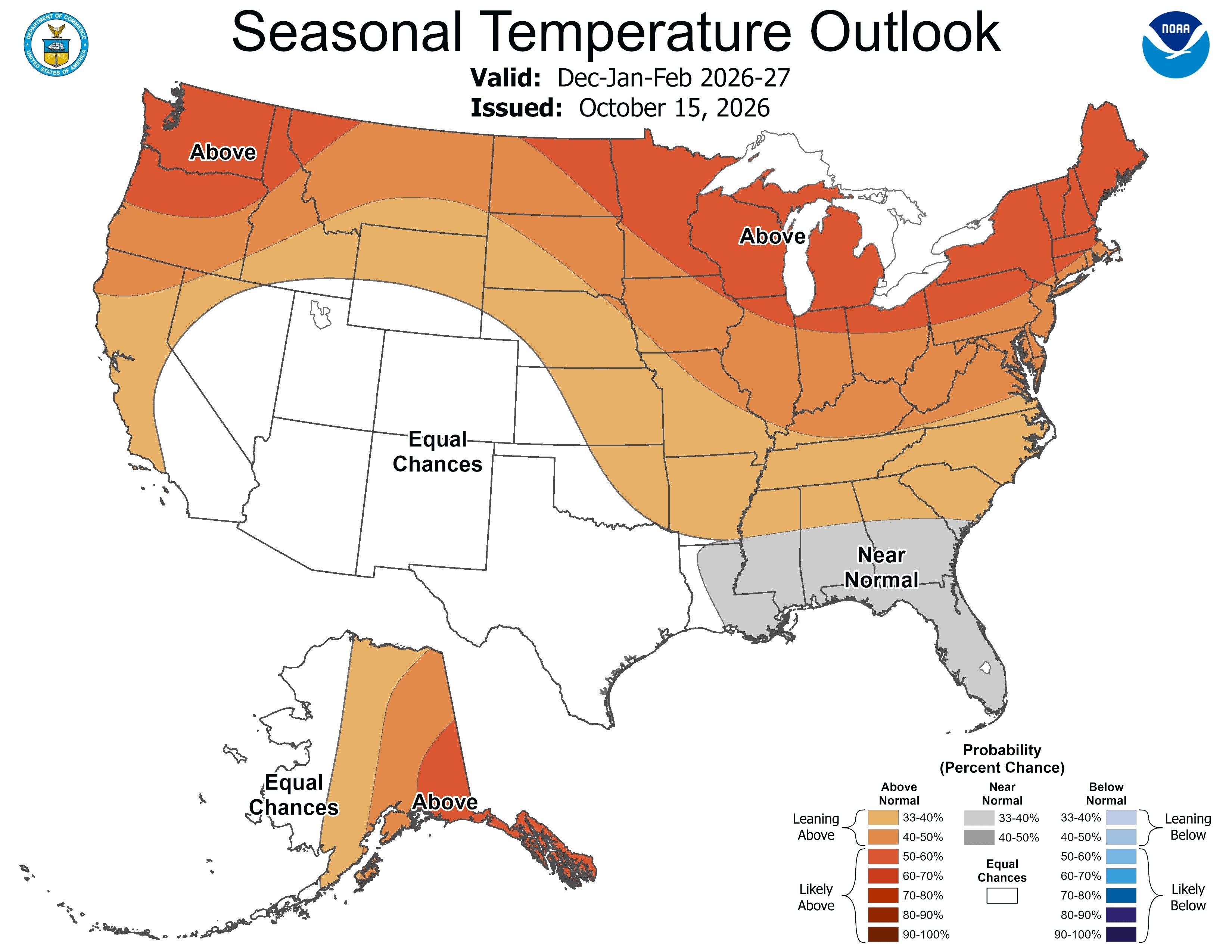
As of late October, climate diagnostics revealed the strongest ocean warming in the eastern equatorial Pacific Ocean on record. Forecast models indicate the warming will continue and Super El Niño 2026 peaks this month. Since 1950, New England has witnessed three Super El Niño winter seasons (1982-83, 1997-98, and 2015-16). As an analog of what winter 2026-27 may bring, let’s review each previous Super El Niño winter.
December: El Niño has a reputation for bringing mild New England winter seasons. The start of the winter season was exceptionally mild in 2015 when December averaged about 10°F above normal. There were 11 days when the maximum temperature exceeded 50°F and 8 days reached the 60s! In December 1982, Boston reached 70°F twice. But not all Super El Niño Decembers were warm. December 1997 was normally cold and snowy.
January: Similarly, two Super El Niño mid-winters were mild (1998 and 2016). Daytime high temperatures reached the 50s on 4-5 occasions respectively for each January. However, January 1983 was brutally cold, featuring a mid-month moderate snowfall followed by an arctic outbreak when local temperatures fell below zero.
February: Late meteorological winter during Super El Niño produced two mild scenarios (1998 and 2016) and one normally cold (and snowy) February (1983). Late winter Super El Niño produced extremes. On Valentine’s Day in 2016, Plymouth plummeted to 10°F below zero after reaching 60°F early in the month. In 1998, 5 days reached the 50s while 2 days dropped to 8°F.
Analog summary: Snowfall is below normal based on the three Super El Niño analogs. The only chance of above normal snowfall is in February. Precipitation amount for the three-month period during Super El Niño averages near normal locally. Overall, the analogs imply a 2-in-3 chance of a very warm winter.
History: As a resident of Hawaii, I witnessed the first Super El Nino climate beginning in late 1982. In Honolulu, an arid start to 1983 with <10% normal rainfall. Super El Niño raised havoc on global weather patterns. The most memorable events, among many, were the flooding rainstorms across Southern California and the brushfires motivated by a horrific Australian drought. In 1982-83, there was little to no climate prediction. All sectors of the globe experiencing the hostile Super El Niño climate were caught off-guard.
What followed was the evolution of modern-day climate forecasts developed by NOAA with the release of the first probabilistic long-lead climate forecast in 1994. Another wave of climate prediction methodology and models followed by an evolving private sector in meteorology when commodities markets deregulated in the late 1990s. The heavy load of analytics used to generate climate forecasts is tailor-made for artificial intelligence.
Nowadays, climate forecast accuracy has improved dramatically.
NOAA winter 2026-27 outlook: Let’s glance at the NOAA meteorological winter 2026-27 probabilistic forecast. Not surprisingly, the temperature outlook indicates likelihood of a mild winter in New England. In fact, the highest probabilities are across New England to the Upper Midwest. In an El Niño winter, much of the time mild Pacific marine air masses are swept across the U.S. (and Canada) and there is great difficulty generating cold, arctic air masses. The mild temperatures cause below-normal snow cover which enhances the milder tendency.
The precipitation outlook favors above normal amounts for the southern half of New England. Stronger storms will generate heavy wet snow, otherwise most precipitation episodes are all rain, especially near the coast. Below-normal snowfall for ski country is anticipated. The big storms for winter 2026-27 are in California and Florida!